Difference between revisions of "Rivington Rd to Isle of Mann"
Jump to navigation
Jump to search
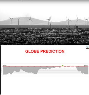
(Created page with "thumb|right|Infrared Photo of Isle of Mann from 90 miles. The Globe model predicts only 60 ft of the highest peak should be visible. Infra...") |
|||
| Line 5: | Line 5: | ||
<Youtube>https://www.youtube.com/watch?v=5OOYkhre_FQ</Youtube> | <Youtube>https://www.youtube.com/watch?v=5OOYkhre_FQ</Youtube> | ||
| + | |||
| + | |||
| + | <html> | ||
| + | <head> | ||
| + | <meta name="twitter:card" content="summary_large_image"> | ||
| + | <meta name="twitter:site" content="@indio007"> | ||
| + | <meta name="twitter:creator" content="@"> | ||
| + | <meta name="twitter:title" content="Rivington Rd to Isle of Mann"> | ||
| + | <meta name="twitter:description" content="Infrared Photo of Isle of Mann from 90 miles. The Globe model predicts only 60 ft of the highest peak should be visible"> | ||
| + | <meta name="twitter:image" content="https://wiki.247flatearth.net/images/thumb/d/d3/IR_photo_Isle_of_Mann.jpg/450px-IR_photo_Isle_of_Mann.jpg"> | ||
| + | </body> | ||
| + | </html> | ||


