Difference between revisions of "Canigó Pyrenees to Barre des Écrins Alps"
Jump to navigation
Jump to search
| (One intermediate revision by the same user not shown) | |||
| Line 1: | Line 1: | ||
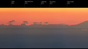
| − | [ | + | [256 miles from 9137 ft elevation - Globe model predicts only 722 ft of Barre Des Ecrins should be visible. The horizon should be at the distance of the far shore.] |
| − | [[File:Panob.jpg|thumb|right|412 KM | | + | [[File:Panob.jpg|thumb|right|412 KM | 256 miles from 9137 ft elevation - Globe model predicts only 722 ft of Barre Des Ecrins should be visible. The horizon should be at the distance of the far shore.]] |
| Line 8: | Line 8: | ||
<meta name="twitter:site" content="@indio007"> | <meta name="twitter:site" content="@indio007"> | ||
<meta name="twitter:creator" content="@"> | <meta name="twitter:creator" content="@"> | ||
| − | <meta name="twitter:title" content=" | + | <meta name="twitter:title" content="Canigó Pyrenees to Barre des Écrins Alps"> |
| − | <meta name="twitter:description" content=" | + | <meta name="twitter:description" content="256 miles from 9137 ft elevation - Globe model predicts only 722 ft of Barre Des Ecrins should be visible. The horizon should be at the distance of the far shore."> |
| − | <meta name="twitter:image" content="https://wiki.247flatearth.net/images/thumb/ | + | <meta name="twitter:image" content="https://wiki.247flatearth.net/images/thumb/3/39/Panob.jpg/450px-Panob.jpg"> |
</body> | </body> | ||
</html> | </html> | ||
Latest revision as of 23:47, 12 March 2021
[256 miles from 9137 ft elevation - Globe model predicts only 722 ft of Barre Des Ecrins should be visible. The horizon should be at the distance of the far shore.]


