Difference between revisions of "Cape Bolton NK to Mount Chōkai Jp"
Jump to navigation
Jump to search
| Line 1: | Line 1: | ||
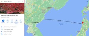
| + | [[File:Cape Boltin NK to Japan.jpg|thumb|Obviously, those mountains which we saw so clearly on the solar disk had to be on a line between us and the rising sun...The distance from the cruiser to that mountain was 480 sea miles.|right]] | ||
| + | |||
"Obviously, those mountains which we saw so clearly on the solar | "Obviously, those mountains which we saw so clearly on the solar | ||
disk had to be on a line between us and the rising sun. And, indeed, | disk had to be on a line between us and the rising sun. And, indeed, | ||
| Line 16: | Line 18: | ||
==References== | ==References== | ||
| + | <html> | ||
| + | <head> | ||
| + | <meta name="twitter:card" content="summary_large_image"> | ||
| + | <meta name="twitter:site" content="@indio007"> | ||
| + | <meta name="twitter:creator" content="@"> | ||
| + | <meta name="twitter:title" content="Cape Bolton NK to Mount Chōkai Jp 1914"> | ||
| + | <meta name="twitter:description" content="Obviously, those mountains which we saw so clearly on the solar disk had to be on a line between us and the rising sun...The distance from the cruiser to that mountain was 480 sea miles."> | ||
| + | <meta name="twitter:image" content="https://wiki.247flatearth.net/images/thumb/c/c6/Paglia_Orba_from_Sallfort.jpg/450px-Paglia_Orba_from_Sallfort.jpg"> | ||
| + | </body> | ||
| + | </html> | ||
Revision as of 02:10, 24 January 2021
"Obviously, those mountains which we saw so clearly on the solar disk had to be on a line between us and the rising sun. And, indeed, by constructing on a chart the aforementioned azimuth of the sun at the moment of its rising, it turned out that this line passed just through the high mountain Tonvumi-yama , located on the north-western part of the Japanese island of Nippon [sic -- he means Honshu], at north latitude 39° 5' and east longitude 140° 10', not far from the city of Akita. The distance from the cruiser to that mountain was 480 sea miles." An accurate calculation gives 897 km or 490 nautical miles." [1]
References
- ↑ K. P. Jessen “Neobyknovennoe yavlenie refraktsii, nablyudennoe v Yaponskom morye,” Izvestiya Imperatovskogo Geograficheskogo Obshchestva 50, 95–100 (1914) https://aty.sdsu.edu/bibliog/bibliog.html


