Difference between revisions of "Mallorca to Tossal de la Muga"
Jump to navigation
Jump to search
m (Indio007 moved page Puig Roig to Tossal de la Muga to Mallorca to Tossal de la Muga) |
|||
| Line 3: | Line 3: | ||
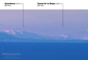
[[File:CROPPED.jpg|thumb|right|Mollorca to Pyranees 302 KM from 1002 meter elevation - globe model predicts Tossal de la Muga is 100 meters under the horizon]] | [[File:CROPPED.jpg|thumb|right|Mollorca to Pyranees 302 KM from 1002 meter elevation - globe model predicts Tossal de la Muga is 100 meters under the horizon]] | ||
https://beyond-horizons.org/2014/12/14/mallorca-pyrenees-muga-307-km | https://beyond-horizons.org/2014/12/14/mallorca-pyrenees-muga-307-km | ||
| + | |||
| + | |||
| + | <html> | ||
| + | <head> | ||
| + | <meta name="twitter:card" content="summary_large_image"> | ||
| + | <meta name="twitter:site" content="@indio007"> | ||
| + | <meta name="twitter:creator" content="@"> | ||
| + | <meta name="twitter:title" content="Puig de Sallafort to Paglia Orba"> | ||
| + | <meta name="twitter:description" content="Mollorca to Pyranees 302 KM from 1002 meter elevation - globe model predicts Tossal de la Muga is 100 meters under the horizon."> | ||
| + | <meta name="twitter:image" content="https://wiki.247flatearth.net/images/thumb/a/aa/CROPPED.jpg/450px-CROPPED.jpg"> | ||
| + | </body> | ||
| + | </html> | ||
Latest revision as of 03:05, 3 January 2021
Mollorca to Pyranees 302 KM from 1002 meter elevation - globe model predicts Tossal de la Muga is 100 meters under the horizon
https://beyond-horizons.org/2014/12/14/mallorca-pyrenees-muga-307-km


